
Bedrock and Glacial Scour: Reading the Geologic Scars of the Cobscook Shoreline

Unlocking the Ancient Shorelines of Cobscook Bay
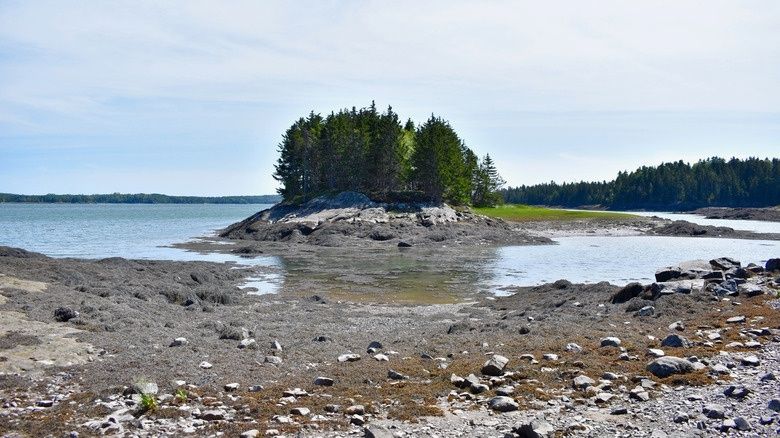
Cobscook Bay is a shoreline of motion and exposure. Twice each day, one of the largest tidal ranges on the Atlantic coast pulls water away from spruce-fringed coves and rocky headlands, revealing ledges, tidal benches, mudflats, channels, and boulder-strewn margins that remain hidden at high water. The changing light is more than scenic. It gives careful observers a moving cross-section through coastal geology, while fog, wind, waves, and recent erosion continually reshape the surface.
The rocks beneath those changing waters preserve two very different chapters of Earth history. Silurian volcanic activity and later tectonic collisions built much of the region’s structural foundation, folding ash-rich layers, volcanic rocks, and older crust into a complicated coastal framework. Much later, during the Pleistocene, the Laurentide Ice Sheet dragged debris across that foundation, polishing exposed bedrock, cutting grooves, and leaving erratic boulders and glacial sediment behind. Along a low-tide ledge or coastal bluff, an observant hiker can learn to distinguish volcanic layering from glacial scoring, and ancient structural breaks from modern wave attack.
Timing the Tides and Reading the Intertidal Zone Safely
Cobscook Bay’s tidal range commonly reaches roughly 20 to 24 feet, although the exact height varies with the lunar cycle, weather, and local conditions. That scale changes the meaning of distance. A route that appears to be a short walk across exposed ledge at low tide may become an isolated pocket of shoreline within a surprisingly brief period. Tidal currents can also accelerate through narrow channels, and a calm surface in one cove does not guarantee calm conditions on an outer shore.
Plan geological observation around a published tide table, but do not treat the predicted low-water time as a deadline for returning. Allow a generous margin before the flood tide begins, especially when exploring unfamiliar ledges, tidal terraces, or mud margins. Rockweed, particularly Ascophyllum nodosum, forms a slippery mat over many intertidal rocks. Mudflats can look firm while concealing soft, waterlogged sediment that grips boots and makes retreat difficult. Incoming water may also surround a hiker from several directions as channels refill.
Regional geology helps explain why the shoreline varies so sharply from one cove to the next. New England’s bedrock coast is a patchwork of resistant rock compartments and softer deposits, and glacial sediment continues to be reworked by waves, runoff, frost, and gravity. For a useful overview of coastal morphology, glacial deposits, and changing sea levels, consult this Maine Geological Survey coastal report.
- Wear footwear with firm, non-slip soles and secure ankle support; smooth-soled shoes are poor protection on wet rockweed.
- Carry a current tide table, a charged phone in a waterproof case, and a paper map or dependable offline map.
- Bring layers, rain protection, water, and a small first-aid kit, since wind and fog can arrive quickly along exposed shores.
- Ask local land managers, park staff, or a knowledgeable community contact about access, closures, shorebird areas, and current conditions.
- Keep the return route in view, and turn around early if fog, rising water, or unstable footing changes the margin of safety.
Deciphering Deep Time in the Volcanic Silurian Bedrock
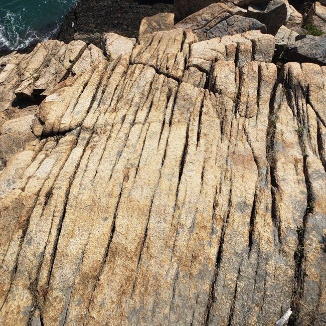
Some of the most compelling exposures around Downeast Maine are not isolated, uniform slabs of stone. They are layered and folded records of volcanic material deposited, buried, altered, and later deformed. Ash that settled from ancient eruptions could compact into fine-grained tuff. Lava flows could cool into basaltic rock, while heat, pressure, fluids, and tectonic movement altered the original minerals and textures. At the shoreline, weathering often emphasizes contrasts between harder and softer layers, creating ribs, grooves, steps, and shadowed seams.
Look first for repetition. A single band may be difficult to interpret, but a series of parallel or tightly folded bands can reveal the direction in which the rock was originally layered and the later forces that bent it. Faults may appear as sharp breaks where layers no longer line up. Shear zones can produce zones of crushed, streaked, or finely foliated rock. Intrusions, including narrow dikes or veins, cut across older structures rather than following them. In the Passamaquoddy Bay region, marine magnetic mapping has helped researchers trace buried structural features and identify fault-related offsets, showing that some of the area’s deep architecture cannot be understood from the exposed shoreline alone.
| Field feature | What to look for | What it may indicate |
|---|---|---|
| Layered volcanic rock | Repeated fine to coarse bands, altered ash textures, or resistant dark layers | Ancient ash falls, lava flows, or volcanic sequences |
| Folded beds | Layers curving into arches, troughs, or tight repeated bends | Compression during tectonic collision |
| Fault or shear zone | Offset bands, crushed rock, polished streaks, or abrupt linear breaks | Movement along a fracture or ductile deformation zone |
| Intrusion | A vein or dike cutting across existing layers | Later molten material entering older rock |
Headlands such as Shackford Head offer useful places to compare these features because exposed rock faces, ledges, and cliff margins provide several viewing angles. The apparent simplicity of a gray or dark outcrop can change when viewed obliquely in low sunlight. Moisture may highlight mineral bands, while dry surfaces reveal weathering differences. Avoid assigning a precise rock name from color alone. A hand lens, a field guide, and careful photographs are more reliable than casual identification, and formal interpretation may require laboratory analysis.
Hunting for Glacial Striations and Chatter Marks
The Laurentide Ice Sheet repeatedly crossed Maine during the Pleistocene, grinding bedrock beneath an immense, debris-laden mass of ice. Pressure and movement polished broad surfaces, while stones frozen into the basal ice scratched and grooved the rock. Glacial erosion also helped shape asymmetrical hills, streamlined ridges, exposed ledges, and the irregular pattern of headlands and coves found throughout the region. The same broad glacial story is documented in nearby coastal landscapes through the NPS Geodiversity Atlas for Acadia National Park.
On a clean, sloping ledge, fine striations may appear as narrow, nearly parallel lines. Deeper grooves are broader and more decisive, sometimes accompanied by a polished surface that reflects light differently from weathered rock. Crescentic chatter marks are short, curved breaks or chips formed when a tool lodged beneath moving ice and intermittently fractured the bedrock. Not every line is glacial. Wave-worn scratches, fractures, lichen boundaries, boot marks, and recent abrasion can imitate striations, so confidence comes from finding several consistent indicators together.
- Choose a broad, low-angle bedrock surface where lichen, loose sediment, and standing water do not obscure the texture.
- View the surface from a shallow angle, moving around it until parallel scratches or polished zones catch the light.
- Trace several lines rather than relying on one mark, and note whether they remain consistent across the exposure.
- Take a bearing with a compass or phone compass, recording the line direction rather than the direction toward which the glacier moved.
- Compare the bearing with regional evidence and nearby exposures. A consistent southeastward trend can support interpretation of ice flow, but local topography and bedrock structure may alter the record.
- Photograph the feature with a scale, such as a boot or field ruler, without placing objects on delicate surfaces or disturbing sediment.
Compass work requires care. A striation records the direction of ice movement across the rock surface, but a line can be read in either of two opposite bearings. Record both possibilities, then use chatter marks, streamlined landforms, and regional mapping to determine the more likely ice-flow direction. Glacial deposits add another layer of evidence. Erratic boulders made of rock unlike the local ledge may have traveled considerable distances, while till contains an unsorted mixture of clay, sand, pebbles, and larger stones left directly by ice.
Prime Field Sites Around Outer Cobscook Bay
Shackford Head State Park provides a strong setting for learning how bedrock, tide, forest, and open water interact. Overlooks offer broad views across the bay, while exposed rock near the coast can show layering, fractures, weathering contrasts, and the hard edges of volcanic outcrops. The most useful observations often come from slowing down rather than covering ground quickly. Compare rock surfaces in shade and sunlight, inspect the orientation of visible bands, and consider how wave exposure has enlarged existing cracks.
Deep Cove and nearby coastal bluffs offer a different perspective. Bluffs may expose till, mixed glacial sediment, or weathered bedrock, while isolated boulders can stand out as possible erratics. Tidal terraces and low benches reveal how water repeatedly occupies different levels across the shore, although a terrace is not automatically an ancient sea level. Some forms result from bedrock structure, storm deposition, ice loading, or modern erosion. Current access conditions vary by property, park rules, weather, and season, so verify permissions and local guidance before setting out.
- Stay on durable surfaces where possible, avoiding trampling of salt-marsh edges, lichens, and unstable bluff faces.
- Do not hammer, split, or remove rock. Photographs and field notes preserve the evidence without damaging it.
- Give shorebirds and other wildlife a wide berth, especially during migration and nesting periods.
- Keep dogs controlled where regulations require it, and prevent them from flushing roosting birds.
- Leave cultural materials, driftwood structures, shells, and unusual geological specimens in place unless local rules clearly allow collection.
- Watch for rockfall, undercut bluff edges, and loose blocks after heavy rain, freeze-thaw weather, or coastal storms.
Ethical fieldwork is especially important in a tidal environment because small disturbances can spread through a narrow intertidal zone. Turning over stones may crush animals sheltering beneath them, and repeated foot traffic can damage slow-growing lichens on exposed ledges. A good coastal naturalist leaves the site looking unchanged, while the record of observations becomes more precise through photographs, sketches, compass bearings, and notes about tide stage and weather.
Walking with a New Perspective on Downeast Shores
A Cobscook shoreline walk can become an encounter with several million years of natural change. Folded volcanic layers speak of ancient eruptions and continental collisions. Faults and intrusions reveal later movement through the crust. Glacial striations and chatter marks record the grinding passage of continental ice, while erratics and till show how that ice transported material across the landscape. Modern tides then return twice daily to expose, wet, polish, and erode the same enduring foundation.
Approach the coast with the patience required by its rhythms. Check the tide, watch the weather, respect private and protected land, and allow enough time to leave the intertidal zone before water closes the route. At the edge of the bay, pause over a polished ledge or a line of folded bands. The stone does not offer its history all at once, but careful observation can make the ancient forces of Downeast Maine tangible beneath the changing light.